Aerospace Industry As An Application Of GIS
A system of computer hardware and software known as a Geographic Information System (GIS) enables users to gather, manage, analyze, and retrieve significant amounts of geographically referenced data as well as associated qualities gathered from various sources.
The primary benefit of GIS is that it is an information system, allowing any digital database that has been created at any point in time to be used in the future and allowing for the quick and effective extraction of any relevant information.
GIS is a powerful tool for managing and analyzing the spatial data needed for any land development activity, and remote sensing is a powerful instrument for collecting spatial data.
One of the areas where GIS is most crucial is aviation. The functioning of planes at the airport and other duties is supported by geographic systems. Aviation GIS must be extremely precise, effective, and dependable. For the airports and planes to smoothly functioning, they must also operate on a pinpoint real-time basis. GIS has the ability to offer dispersed and multi-tasking processing. Manual techniques are vague in achieving this.
The use of computers, software, and data through information technology and geographic information systems (GIS) enables stakeholders in the aviation industry to more easily identify and visualize market trends, patterns, and obstacles than they might be able to do with data on paper and in tabular formats. IT and GIS can integrate together to improve the aviation industry and supports in its growth.
Information from the aviation, hospitality, and travel industries paired with spatial data must be digitized (for instance, by developing or obtaining data from the census or private companies for satellite data). The GIS act as a boon to the construction industry owners to plan the site selection of the airports and create infrastructure at a place away from the residential areas, dispensaries, and schools
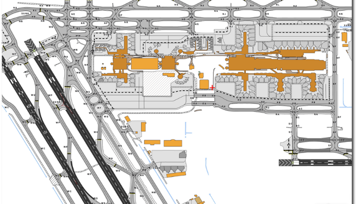
A few of the merits of GIS in the aviation sector are as follows:
1. GIS hands over the airport layout design of the real world in a miniature form
2. Integrated GIS, CAD, and Planning applications support air space planning, routing, and other research activities for continuously enhancing aviation sector upliftment and safety
3. GIS grants capacity planning, construction management, and lease management
4. An information portal for the public that needs online GIS spreads awareness of the social and environmental effects of aviation hazards in airports and other aviation infrastructure