High-Resolution Satellite Imagery on Aerodrome
High-resolution Satellite Imagery, satellite imagery
Imagine overseeing an expansive aerodrome from hundreds of miles above the Earth. With high-resolution satellite imagery, airport managers can see every detail of the aerodrome's layout—from the runways to the farthest taxiways.
This capability is not just about having a bird’s-eye view; it's about ensuring precision in every operational aspect, enhancing safety, and planning for the future. A recent study showed that airports using high-resolution satellite imagery have improved their operational efficiency by up to 25%, demonstrating the significant impact of this technology on global aviation.
Exploring High-Resolution Satellite Imagery
High-resolution satellite imagery provides highly detailed visual data captured from satellites, offering clear and precise images of the Earth's surface. This technology is essential for industries that require exact spatial accuracy, such as aerodrome management and planning.
The process begins with data capture, where advanced satellite cameras collect images with high pixel resolution, ensuring every detail is recorded accurately. After capture, image processing is carried out using sophisticated algorithms that enhance clarity and refine details for better interpretation. These steps ensure that the imagery remains up-to-date and provides reliable data, supporting crucial decision-making processes in aviation and beyond.
Optimizing Runway Planning and Maintenance
Runways are the heart of any airport. They must be in top condition to handle landings and take-offs safely. Proper planning and maintenance ensure efficiency and prevent delays.
|
Aspect |
Traditional Methods |
With High-Resolution Satellite Imagery |
|
Condition Monitoring |
Manual inspections time-consuming |
Automated detection of cracks and surface wear |
|
Drainage Assessment |
Visual checks, less accuracy |
Identifies water accumulation areas with precision |
|
Repair Scheduling |
Based on routine maintenance |
Predictive maintenance reduces sudden repairs |
|
Safety Compliance |
Relies on physical surveys |
GIS-integrated maps ensure regulatory adherence |
|
Operational Efficiency |
Prone to delays due to unknown issues |
Improves scheduling, reduces unexpected runway closures |
These proactive strategies keep runways safe, reducing the risk of accidents and enhancing overall efficiency.
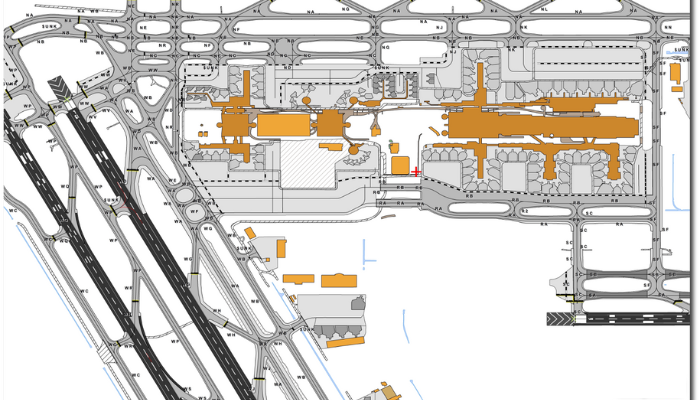
Satellite Imagery in Aerodrome Mapping and Planning
High-resolution satellite imagery is transforming how aerodromes are mapped and planned. Traditional methods relied on ground surveys and manual assessments, which were time-consuming and often lacked precision. Now, aerial imaging provides a comprehensive, real-time view of an entire aerodrome, ensuring every detail is accurately captured.
One key advantage is layout optimization, which helps in designing aerodrome structures that maximize both efficiency and safety. Planners can analyze runways, taxiways, and terminal positions to reduce congestion and improve aircraft movement. Additionally, infrastructure development benefits from this technology, as it supports the planning and execution of new projects or expansions. Whether it’s adding a new terminal or modifying a runway, aerial imaging ensures precise decision-making.
With such detailed insights, every square meter of an aerodrome is effectively utilized. This leads to better resource management, improved operational efficiency, and enhanced long-term planning for future aviation demands.
Improving Emergency Response Coordination
Quick response times during emergencies are crucial in aviation. Having a well-structured action plan can save lives and minimize damage.
- Faster Incident Detection: Real-time monitoring helps detect accidents, fires, or mechanical failures instantly.
- Optimized Fire and Rescue Routes: Response teams can access the best possible paths to reach affected areas quickly.
- Better Coordination with External Agencies: Enables smoother communication with medical teams, law enforcement, and disaster management units.
- Enhanced Evacuation Planning: Helps identify safe exit routes and assembly points for passengers and staff.
- Continuous Readiness Assessment: Regular drills and scenario simulations improve preparedness for real-life emergencies.
A well-coordinated response system ensures that unexpected situations are handled swiftly and efficiently.
Advantages of Aerial Imaging in Aerodrome Operations
Integrating high-resolution satellite imagery into aerodrome operations significantly enhances both daily activities and long-term planning. One major benefit is enhanced navigation, as it provides pilots and ground crews with precise geographical data, improving safety during takeoff, landing, and taxiing. Accurate mapping ensures better situational awareness, reducing the chances of miscalculations.
Additionally, maintenance scheduling becomes more efficient with aerial imaging. It helps identify areas needing repairs, such as worn-out runways or damaged taxiways, allowing for timely interventions. By optimizing these aspects, aerodromes can operate more smoothly, minimize delays, and ensure long-term infrastructure reliability for safer air travel.
Real-World Application:
Tokyo Narita Airport uses aerial imaging to efficiently manage its large and complex operations.
These examples underline the practical benefits and the critical role aerial imaging plays in modern aerodrome management.
Managing Environmental Impact and Land Use
Sustainable operations are becoming a priority for the aviation industry. Proper land management reduces negative environmental effects and supports long-term growth.
- Monitoring Nearby Water Bodies: Ensures airport operations do not contaminate lakes, rivers, or wetlands.
- Assessing Noise Pollution Levels: Helps in designing noise reduction strategies to minimize impact on surrounding communities.
- Tracking Vegetation Growth: Prevents wildlife hazards and ensures clear visibility around runways.
- Identifying Potential Expansion Areas: Helps in planning future infrastructure projects without disrupting ecosystems.
- Regulating Air Quality: Monitors emissions and supports efforts to maintain compliance with environmental standards.
Balancing airport expansion with sustainability creates a better future for both aviation and the environment.
Enhancing Ground Traffic Flow
Managing aircraft movement on the ground is just as important as controlling flights in the air. A well-organized ground system helps prevent congestion, improves efficiency, and reduces delays. One key factor is reducing taxi time, where efficient route planning allows aircraft to move quickly between runways and gates. Optimizing gate assignments further helps airlines manage space effectively, minimizing passenger wait times.
Proper vehicle movement management ensures safe coordination between aircraft, baggage handlers, fuel trucks, and service vehicles. By preventing bottlenecks and integrating with air traffic control, airports can streamline operations, making ground movement smooth, safe, and highly efficient.
Supporting Infrastructure Expansion and Upgrades
As air travel demand grows, airports must expand and upgrade their facilities to accommodate more passengers and flights.
- Planning New Terminal Locations: Helps determine the best sites for expanding passenger terminals without disrupting existing operations.
- Assessing Space for Additional Runways: Ensures new runways are built in optimal locations to handle increased flight volume.
- Enhancing Cargo Facilities: Supports the logistics sector by improving freight handling areas for faster processing.
- Evaluating Road and Parking Needs: Helps optimize parking lots and access roads for passengers and airport employees.
- Maximizing Land Utilization: Prevents space wastage and ensures every available area is used efficiently.
Future Directions in Aerodrome Management
The future of aerodrome management will rely even more on aerial imaging, with new technology offering better details and faster updates. One major advancement is automated analysis, where AI will automatically examine satellite images, spotting changes and potential issues without needing human intervention.
Another improvement is increased update frequency, meaning satellite images will be refreshed more often, giving near real-time insights into airport conditions. These innovations will help aerodromes run more efficiently, improve safety, and allow for better planning. As technology continues to evolve, managing aerodromes will become even smoother and more accurate.
Final Thoughts
As we look to the future, the role of high-resolution aerial imaging in aerodrome management is set to become even more integral. The clarity and precision provided by this technology make it an indispensable tool for modern aviation professionals.
With advancements in AI-driven analysis and frequent image updates, aerodrome management will continue to improve, ensuring smooth operations and safer air travel. Cost-effective solutions like AMDB by SATPALDA play a crucial role in airport pre-planning, security, and navigational mapping. By offering highly detailed aerodrome maps and terrain data, they help aviation professionals make informed decisions with precision.
To explore how AMDB can support airport planning and design, visit amdb.biz.
FAQs
1. What is high-resolution satellite imagery?
It's detailed visual data from satellites that offer clear, precise views of the Earth, used for mapping and operational planning in aerodromes.
2. How does aerial imaging enhance aerodrome safety?
Providing accurate layouts and real-time updates helps manage air and ground traffic safely.
3. Can aerial imaging support aerodrome expansion projects?
Yes, it provides detailed terrain and infrastructure data crucial for planning and executing expansion projects.
4. What future advancements are expected in aerial imaging technology?
Expect more frequent updates and advanced AI analysis for automated monitoring and planning.
5. How does this technology help with airport expansion?
It helps plan new runways, terminals, and parking areas by providing accurate land and infrastructure data, ensuring smooth expansion without disruptions.