technology. The image showcases a high-tech control center w.webp)
Revolutionizing Drone Airports with 3D Mapping and AMDB Technology
Are you ready for the drone revolution? Picture this: a busy airport where unmanned aerial vehicles zip through the air, delivering packages and conducting surveys with pinpoint accuracy.
This is the future of aviation, and it's happening right now. Drone Airports are taking off, powered by 3D Mapping Technology. In fact, the global drone analytics market is set to soar to $28.57 billion by 2030.
Let's explore how this tech is transforming the way we think about air travel.
The Rise of Drone Airports
Drone airports are no longer a pipe dream. They're popping up all over the world, changing the game for logistics, surveillance, and more. But what exactly are these futuristic facilities?
Simply put, drone airports are specialized hubs designed for unmanned aerial vehicles (UAVs). They're equipped with advanced systems for takeoff, landing, and maintenance of drones. Unlike traditional airports, these spaces cater specifically to the unique needs of UAVs.
Why the sudden boom? Well, drones are incredibly versatile. They can handle tasks that are too dangerous, costly, or time-consuming for humans. From package delivery to emergency response, the applications are endless.
But here's the kicker - running a drone airport isn't as simple as setting up a few landing pads. It requires a whole new approach to air traffic management and infrastructure planning. That's where 3D Mapping Technology comes in.
3D Mapping Technology: The Game-Changer for Drone Airports
3D Mapping Technology is revolutionizing how we design and manage drone airports. But what exactly is it?
At its core, 3D mapping uses drones equipped with special cameras and sensors to create detailed, three-dimensional models of physical environments. It's like Google Maps on steroids.
For drone airports, this tech is a game-changer. Here's why:
1. Precision Planning: 3D maps provide an incredibly accurate layout of the airport and its surroundings. This helps planners optimize space and design efficient flight paths.
2. Safety First: By mapping potential obstacles and no-fly zones, 3D technology enhances safety for both drones and nearby communities.
3. Real-Time Updates: As the airport evolves, 3D mapping can quickly capture changes, ensuring all operators have the most up-to-date information.
4. Cost-Effective: Compared to traditional surveying methods, drone-based 3D mapping is faster and more affordable.
5. Enhanced Visualization: 3D models offer a more intuitive way to understand and interact with the airport environment.
But the benefits don't stop there. Let's find out how this technology is reshaping the drone airport landscape.
Transforming Airport Design with 3D Mapping
Designing a drone airport is no small feat. It's a complex puzzle of runways, charging stations, and maintenance areas. 3D Mapping Technology is making this process smoother and more efficient than ever before.
First off, 3D mapping gives designers a bird's-eye view of the entire site. They can see exactly how different elements fit together, spotting potential issues before breaking ground. This saves time and money in the long run.
But it's not just about the big picture. 3D mapping captures minute details too. Designers can zoom in on specific areas, measuring distances and elevations with incredible accuracy. This level of precision is crucial for creating safe and efficient drone flight paths.
Moreover, 3D models aren't static. They're dynamic tools that can be easily updated as plans change. Designers can experiment with different layouts, testing various scenarios virtually before committing to real-world changes.
The result? Drone airports that are optimized from the ground up, designed to handle the unique challenges of unmanned aerial traffic.
Enhancing Safety and Efficiency with 3D Mapping
Safety is paramount in any aviation setting, and drone airports are no exception. 3D Mapping Technology is playing a crucial role in making these facilities safer and more efficient.
For starters, 3D maps provide a comprehensive view of the airport's surroundings. This includes nearby buildings, trees, power lines, and other potential obstacles. Armed with this information, operators can create safe flight corridors and no-fly zones.
But the benefits go beyond just avoiding obstacles. 3D mapping also helps optimize traffic flow within the airport. By analyzing the 3D model, operators can identify bottlenecks and design more efficient routes for drones to follow.
What's more, 3D mapping isn't a one-time thing. Regular scans can detect changes in the environment, such as new construction or natural growth. This ensures that safety measures are always up-to-date.
The result? A safer, more efficient drone airport that can handle high volumes of traffic with ease.
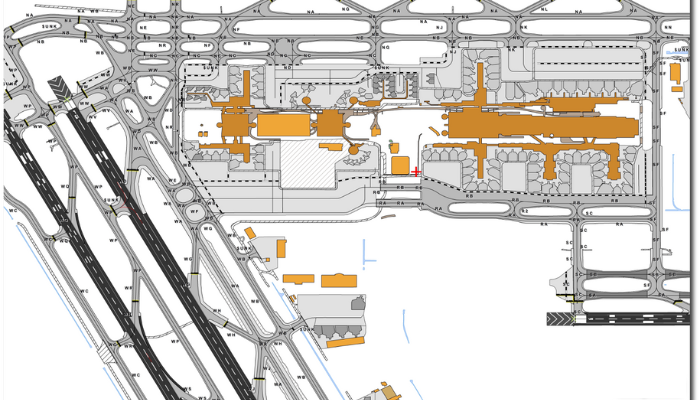
AMDB: The Brain Behind Drone Airport Operations
Now, let's talk about the unsung hero of drone airports - the Aerodrome Mapping Database (AMDB). Think of it as the brain that keeps everything running smoothly.
An AMDB is a detailed digital representation of an airport. It includes everything from runways and taxiways to buildings and navigation aids. For drone airports, this information is absolutely critical.
Here's why AMDB is so important:
|
Aspect |
Description |
|
Precision Navigation |
AMDBs provide drones with exact coordinates for takeoff, landing, and navigation within the airport. |
|
Obstacle Avoidance |
The database includes information on all potential obstacles, helping drones steer clear of danger. |
|
Efficient Routing |
With detailed layout information, AMDBs help plan the most efficient routes for drones. |
|
Real-Time Updates |
AMDBs can be updated in real-time, ensuring all operators have the latest information. |
|
Regulatory Compliance |
AMDBs help ensure that drone operations comply with all relevant aviation regulations. |
By combining 3D Mapping Technology with AMDB, drone airports can create a powerful system for managing complex aerial operations.
Final Thoughts
Drone Airports and 3D Mapping Technology are reshaping the aviation landscape. From enhancing safety to boosting efficiency, the benefits are clear. As we look to the future, one thing is certain - the potential of drone airports is sky-high.
Ready to explore how this technology can benefit your operations? Contact us to learn more and start your journey into the exciting world of drone airports.
FAQs
1. How accurate is 3D mapping for drone airports?
3D mapping for drone airports can achieve centimeter-level accuracy. This precision is crucial for safe and efficient drone operations.
2. Can existing airports be converted into drone airports?
Yes, existing airports can be adapted for drone use. 3D mapping is essential in this process, helping to identify necessary modifications and optimize layouts for UAV operations.
3. How often should 3D maps of drone airports be updated?
The frequency of updates depends on the airport's surroundings and operational needs. However, many experts recommend quarterly updates to ensure accuracy and safety.
4. What training is required to operate a drone airport?
Operating a drone airport requires specialized training in UAV operations, air traffic management, and 3D mapping technology. Specific requirements may vary by location and regulatory environment.
5. How do drone airports handle bad weather conditions?
Drone airports use advanced weather monitoring systems integrated with 3D mapping data to assess flight conditions. This allows for real-time decision-making on whether it's safe for drones to operate.
6. Can drone airports operate at night?
Yes, many drone airports are equipped for 24/7 operations. 3D mapping and lighting systems help ensure safe navigation even in low-visibility conditions.
7. How do drone airports manage airspace conflicts with traditional aircraft?
Drone airports use sophisticated air traffic management systems that integrate 3D mapping data. These systems help coordinate drone flights with traditional air traffic, ensuring safe separation and avoiding conflicts.